 |
|
| Allalinhorn–Feechopf–Alphubel Traverse |
| Difficulty Schedule Maximum
Ratio Combine
with: |
This is a big day, wandering over three very high summits, two of them, the Allalinhorn and Alphubel, over 4000 meters. It is a bit surprising that it can be done in one day from town. But with a starting point of almost 3500 meters at the Mittel Allalin lift station it all becomes feasible. But it is still a considerable outing, up and down, over hill and dale, on both rock, ice and glacier. The Allalinhorn and Alphubel are two of the high peaks on the crest between Zermatt and Saas Fee. Both summits are glacier and snow/ice climbs by their normal routes. The easy access from Saas as well as the fact that they usually present few major technical challenges makes them quite popular. The Feechopf is a smaller summit on the connecting ridge between these peak. The traverse over the Feechopf brings in a bit of variety to the climbing as it includes a fair bit of rock, mostly on an exposed and very fine ridge crest. From Saas we ride the lift system to Mittel Allalin, the highest station in the area. Once on the glacier we climb up among some large crevasses as we gain the Feejoch, the saddle between the Feechopf and the Allalinhorn. Turning left we climb the normal route on the Allalinhorn on steeper but straightforward snow and ice slopes. After returning to the Feejoch, we continue west on the crest, skirting a few towers as necessary to reach the summit of the Feechopf at 3888 meters. From here we descend about 100 meters to the Alphubeljoch at the foot of the South Ridge of the Alphubel. A fine snow arete is followed for quite a way with great views on both sides of the pronounced ridge. The final icy slopes to the broad summit are fairly steep, an good cramponing skills are needed here. For the descent of the Alphubel we have a choice of either retracing our steps to the Alphubeljoch, or we can go down the normal route on the eastern flank of the mountain. Either way we descend the Fee Glacier to the return to the Längflue lift at 2868 meters and continue back to Saas Fee. |
||||
| There are a number of ways to alter this itinerary,
and energy levels and conditions may dictate a change. First it is possible
to skip the ascent of the Allalinhorn, starting right off with the Feechopf
Traverse. Another option is to skip the Alphubel and descend to the Längflue
lift directly from the Alphubeljoch. Addtionally, we can stay in nearby huts to include other peaks. We discuss this in detail below under the heading of "Combinations". |
 |
|
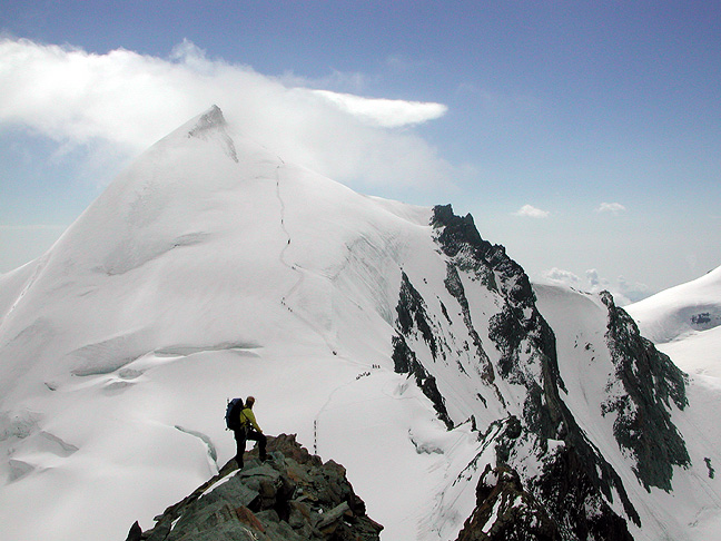
| Allalinhorn from the Feechopf | |
Difficulty The technical difficulties on this combination of routes are not great. There are some moderately steep snow/ice slopes near the summit of the Alphubel and some stiff 4th class rock climbing on the Feechopf, but these sections are limited in length. The main challenge here is aerobic. This is a long day at high altitude and good fitness is a must. Prerequisites This is a good climb for very fit climbers who are comfortable with fairly steep french technique cramponing and exposed rock scrambling. Combinations There are a couple combinations worth noting. One is to start from the Britannia hut and climb the Allalinhorn via the Hohlaubgrat. This adds a day to the itinerary and gives a technically more demanding outing. Another option is to descend from the Alphubeljoch to the Täsch hut on the west side of the peak. From here, we can climb the Rimpfischhorn and descend to Zermatt. By combining both the Hohlaubgrat and the Rimpfischhorn with the Allalinhorn-Alphubel traverse we can enjoy a 3-day outing, climbing 4 summits, 3 of them over 4000 meters. |
||||
 |
|
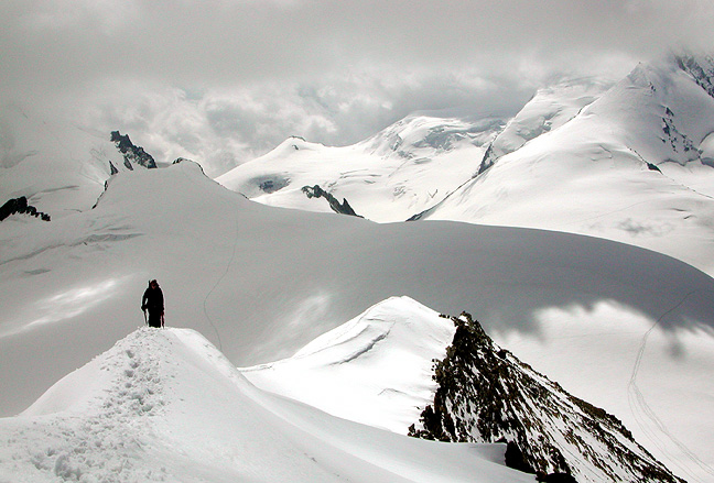
| Climbing on the South Ridge of the Alphubel | |
 |
Kathy Cosley & Mark Houston AMGA Certified • SNGM members All images, layout and text ©2004 Cosley & Houston Alpine Guides, All Rights Reserved |
|
Your Comments -
more info
|