 |
|
| Aconcagua Expedition |  |
|
Difficulty Dates Maximum
Ratio See
also: |
At 6962 meters (22,841 feet) above sea level, Aconcagua is the highest peak in the world outside of Asia. It is a major expeditionary goal. Despite its relatively easy technical difficulty the peak still turns back many alpinists. Success rates on Aconcagua are scarcely higher than those on Mount McKinley, a peak with its own fearsome reputation. The reasons for Aconcagua's challenge lie in its great height and difficult weather. Perhaps it is the availability of a technically easy route which causes many climbers to underestimate the peak. Too frequently one hears of severe, and occasionally fatal altitude illness - illness that could have been prevented with a more patient approach. Likewise the weather also has taken its toll on many expeditions. Though the climate is generally dry, Aconcagua is subject to intense winds. Climbers must learn to wait for the correct conditions. Too many groups have rushed up the peak, bringing only a minimum of food an fuel, only to find that the summit day they have selected offers only marginal weather, and only a marginal chance of summit success. There are four main ingredients to a successful Aconcagua expedition. They are planning, patience, fitness, and last, a bit of luck. Over the years we have made almost 10 expeditions to the peak, and we are continually reminded of the importance of these factors.
The climb begins with planning. Good and appropriate equipment, allowing adequate summit attempt days, slow and methodical movement up the peak to allow for thorough acclimatization, including enough extra days to sit out periods of poor weather - all these are part of good planning. Patience is a key word in high altitude mountaineering. Many time we have seen parties battle their way upward in poor weather and conditions, unwilling or unable to wait for the inevitable improvement. After a brief and challenging stay up high in the wind, they come down, battered, just as the conditions improve. Even sadder, we have seen many expedition leave the peak without having made a serious attempt, simply unwilling to believe that the weather will get better. And most tragically, climbers who ascend too fast play Russian roulette with high altitude pulmonary or cerebral edema. Patience is key. Fitness is another necessary ingredient. Climbers need the kind of fitness which enables them to keep going all day long. Because of the extended nature of the climb and its brutal weather and cold, packs are often large and heavy. Legs, lungs and heart are the necessary ingredients. Psychological fitness is also critical. Successful climbers have a strong combination of drive and patience. Tent life is not for everyone. Living in close proximity for weeks on end takes its toll. Maintaining drive can be a challenge. But it is drive that keeps us moving upward, and ultimately, finds us on the summit. In our climbs of Aconcagua, we have enjoyed remarkable summit success, with the vast majority of our climbers reaching the top. As we look back on those expeditions which have not reached the highest point, we see that our luck was against us. Good planning, preparation and fitness were only part of the picture. Even for the best team, weather can preclude a push to the summit. This is the reality of mountaineering. The unknown is what draws us. Were the outcome a certainty, the challenge would be halved, and the attraction of trying gone. |
|||||
More Photos Click here to see a gallery of some 40 photos showing various parts of the route. See photos from our 2011-2012 trip in our Recent Trips Gallery. Our Itinerary Our preferred route on Aconcagua includes a traverse of the peak - ascending via the Rios Vacas and Relinchos, traversing across to the north ridge to establish a high camp at Col Cólera where the routes from the Horcones and Vacas sides meet. After our summit bid, we descend down to the northwest and out the Horcones valley. The Traverse offers a number of advantages and opportunities.
Program Prerequisites While Aconcagua is not technically demanding, it does require a high level of fitness. Packs can be quite heavy, especially on the descent when we have to move all of our equipment from White Rocks Camp down to Plaza de Mulas Base Camp in one single carry. And as with many long expeditions, a high level of patience and stamina and endurance are also required. Climbers need to be in excellent physical condition. Previous illness-free high altitude experience (to a minimum of about 4000 meters) is required. Experience at altitudes of 6000 meters is recommended but not required. |
 |
|
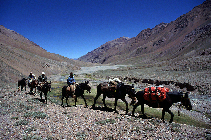
| Our mule team trekking into the Vacas Valley | |
Aconcagua
Traverse Itinerary |
|
Day 1 |
Arrive in Mendoza, Argentina. Mendoza is a lovely city with tree-lined avenues and shady outdoor cafes. There is a strong European influence here, easily seen in the faces of the people and their cultures and customs. It is summer here, a pleasant break from the winter weather of the Northern Hemisphere. |
Day 2 |
In the morning we will pick up our Aconcagua National Park climbing permits (all expedition members must be present) before continuing our drive into the mountains. We will be staying in Penitentes, named for nearby Cerro Penitentes, referring to the unique rocky towers on its slopes, resembling the neve penitentes we may encounter higher on our climb. In the afternoon we will pack up our equipment, divide it into appropriate loads for the mules and at last, enjoy a good meal, our last "indoors" dining for some time. Penitentes is about 2600 meters (8500 feet) above sea level, and it is here that we begin the long process of acclimatization. |
Day 3 |
This is our first day of the three-day trek to Base Camp at Plaza Argentina. Because the day's walk is only about 5 hours long, a comfortably late start is made. We are driven about 10 kilometers downstream to Punta de Vacas. Here we start our walk up the Rio Vacas. Normally our mules, and camping equipment, arrive an hour or two after we arrive at Pampa Leñas, our camp location. |
Day 4 |
As we trek further into the mountains the upper Vacas valley widens out and becomes more gentle. Just a few minutes before arriving at our camp near Casa de Piedra, we get our first view of Aconcagua, at the head of the Relinchos Valley. |
Day 5 |
On our last day of trekking into Base Camp, we leave the Rio Vacas and turn west up the Rio Relinchos. Unlike the Vacas, the lower reaches of the Relinchos are a steep walled and narrow canyon. We cross the river several times in the course of the day and often see herds of guanacos, a smaller cousin of the llama. Finally, we arrive at our Base Camp, Plaza Argentina at 4200 meters, 13,800 feet. The days and nights we have spent on the trek and in Penitentes are essential to acclimating and our future summit success. Our mules will have dropped off our equipment in Base Camp. We meet them on the trail as they make their long ride out to Pampa Leñas. |
Day 6 |
Day 6 is a rest day in Base Camp. Though it really is a pleasant rest, there is still work to do. Gear needs to be sorted, a quick and brisk wash may be in order, along with an opportunity to catch up in our journals. Once we move above Base Camp, everything we carry up will need to be carried over to the other side of the mountain. Going light is critical, and we pear down our equipment from the luxury of Base Camp to the frugal needs above. Later, once we are sure we will complete our traverse, our mule handler will pick up our cached gear in Base Camp and carry it out to await us in Penitentes. |
| Day 7 | On day 7 we make a carry up to Camp One at about 4970 meters, 16,300 feet. The route first takes us across the lower reaches of the rubble covered and gentle Ingles Glacier. As we approach camp the way steepens, finally arriving at a large flat area. We cache our loads and descend again to Base Camp. The carry to Camp One is our first real taste of altitude and most of us arrive back at Base ready for dinner and a warm bed. |
Day 8 |
Second rest day in Base Camp. A successful trip depends on taking time to acclimate, and it is better to spend time now, rather than regret a too-quick ascent later. |
Day 9 |
On our 9th day we move to up to Camp One. |
Day 10 |
Day 10 we make a carry to Camp Two, also known as "Guanacos" located at about 5450 meters, 17,900 on the northern slopes of the peak. |
Day 11 |
On day 11, if weather and rates of acclimatization permit, we will move up to Camp 2. |
Day 12 |
Our 12th day we carry up to High Camp at Col Cólera, about 5970 meters, 19,600 feet. Once we are sure we will be successful in our traverse of the peak, we will send a message by radio to our mule handler and request that he pick up equipment we left in Base Camp. |
Day 13 |
On Day 13 we will move up to High Camp at 5970 meters. |
Day 14 |
Often we take a rest day at High Camp. But if weather and acclimatization permit, we can make a summit attempt on this day. |
Day 15 |
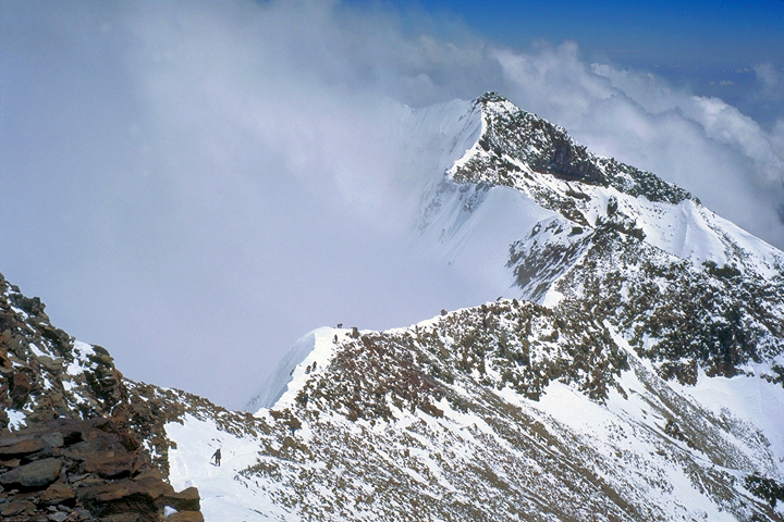
Our first likely summit day. Rising very early, we are off before light, climbing by headlamp. From High Camp, we ascend south directly towards the summit. In about 150 vertical meters we encounter the normal route coming in from the "Berlin" camp. From here the route climbs on the east side of the north ridge, arriving at Independencia, a small and dilapidated hut at about 6400 meters, 21,000 feet. Above a short slope leads to Paso del Viento (Pass of the Winds) where we cross over onto the west side of the ridge. Here, we can see the rising traverse line into the Canaleta. The Canaleta is a notorious part of the route, a long and occasionally loose wide couloir. With careful route finding most of the loose climbing is avoided, but the high altitude makes the climbing quite demanding. The Canaleta leads us to the last part of the route, a spectacular summit ridge. Views over the nearby 3000 meter high South Face are mind boggling. Very soon the summit is reached. Our descent retraces our steps back to camp at Col Cólera. Summit day is a very long day and it is not uncommon to arrive back at camp in the late afternoon, very tired, (but happy). |
Day 16 |
Additional summit day. |
| Day 17 | Additional summit day. |
| Day 18 | Additional summit day. |
| Day 19 | On our second to last day we pack up all of our camp and descend to the tent city of Plaza de Mulas, at about 4380 meters, almost 1900 meters, 6000 feet, below. The descent is straightforward, and usually takes us about 5 to 6 hours. For all its primitive nature Plaza de Mulas feels more like civilization than anything we have seen in some time. Here we can buy bear or pop, are served a fine dinner of salad, potatoes and legendary Argentine beef. But the best part of our arrival in Plaza de Mulas is the warm, oh-so-thick air. |
| Day 20 | On our 20th day we rise early for the hike out the Horcones river valley. This is a 7 hour walk, which we make with only very light packs. Our heavy overnight gear and climbing equipment will be picked up and carried out by mule. The walk down the Horcones is a wonderful way to end the trip. The varied color of the huge rock walls, the large expanses of flat river bottom, with scarcely a plant in sight, and the gradual reentry into greenery and lower elevation life, are all memorable. We are picked up at the trailhead and driven back to Penitentes. Our gear, which has been carried out by mule arrives there shortly after us. If all goes according to plan, and our gear is scheduled to be out that evening, we can arrange transport back to Mendoza. If the gear is late coming out, we may elect to stay in Penitentes this evening and return to Mendoza the following day. |
| Day 21 | Though we plan to travel back to Mendoza late on our 20th day, we prefer to keep this day in reserve, in the event that our mules are too late coming out to effectively do a transfer. In that case we spend the night of the 20th day in Penitentes, and return to Mendoza on the 21st day. If we return to Mendoza on the day 21, we have most of a free day to enjoy the town and yet another fine dinner before we depart the following day. |
| Day 22 | Depart for home. |
 |
|
| White Rocks camp at sunset. | |
 |
Kathy Cosley & Mark Houston AMGA Certified • SNGM members |
|
 |
|
| Looking towards the west summit from the Canaleta. | |
All images, layout and text ©2011 Cosley & Houston Alpine Guides, All Rights Reserved